Name | Type | Output File Formats | OS | Price |
|---|---|---|---|---|
AerialClose-Range | ply, vrml | WindowsmacOSLinux | Free | |
AerialClose-Range | abc, obj | WindowsLinux | Free | |
AerialClose-Range | geotiff, ply, xml | WindowsmacOSLinux | Free | |
AerialClose-Range | MVE | WindowsmacOS | Free | |
AerialClose-Range | ply | LinuxWindowsMacOS | Free | |
AerialClose-Range | obj, ply | WindowsmacOSLinux | Free | |
AerialClose-Range | ply | WindowsmacOSLinux | Free | |
AerialClose-Range | ply, obj, fbx, pdf 3D, u3d, dae, pts, ptx, xyz, txt, las, e57 | Windows | Limited free version and paid version from €149+tax | |
AerialClose-Range | asc, cl3, clr, e57, fls, fws, isproj, las, pcg, ptg, pts, ptx, rds, txt, xyb, xyz, zfs, zfprj | Windows | From $40/month or $325/year | |
AerialClose-Range | fbx | WindowsmacOSLinux | From $179 | |
AerialClose-Range | 3ms, 3sm, kml, dae, fbx, obj, dae, stl | Windows | On request | |
Aerial | .asc, geotiff, .las | Windows | From $295/month | |
AerialClose-Range | ENH, NEH, DXF, PLY, PDF, LAS, PNG, GTIFF | Windows | From $350/month | |
Aerial | dxf, GeoTIFF, las, obj, xyz | WindowsmacOSAndroidiOS | $149/month or $99/month when billed annually | |
AerialClose-Range | All currently known image formats | Windows | On request | |
AerialClose-Range | TXT, CSV, PTS, LAS, PLY, DXF, KML | Windows | $2,495 | |
Aerial | img, igg, ovr. l, noaa, rpf, ddf, dem, til, dt2, ecrg, hdr, xml, ecw, url, ant, dig, alg, ers, gis, lan … | Windows | On request | |
AerialClose-Range | PLY, OBJ, LAS | On request | ||
AerialClose-Range | 3ds, 3dm, dxf, igs, kml, kmz, las, ma, ms, obj, pts, byu, facet, iv, ply, stl, txt, wrl | Windows | One time fee of $995 or from $59/month | |
Aerial | obj, fix, dxf, las, las, kml, tif, osgb, slpk, shp | WindowsmacOSAndroidiOS | From $160/month billed yearly as $1920, or $320/month | |
AerialClose-Range | jpg, png, XYZ, XYZRGB, tiff, bmp, dib, rle, jpeg, jpe, jfif, exif, exr, tif, wdp, jxr, dds, KML, KMZ, obj, ply, partlist, fbx, dxf, dae, bvh, htr, trc, asf, amc, c3d, aoa, mcd, wmv, mp4 | Windows | From $19.90 for 2000 "PPI credits", or $249/month | |
Aerial | Windows | On request | ||
AerialClose-Range | Windows | On request | ||
Aerial | GeoTIFF, png, las, obj | WindowsmacOS | From $57 |
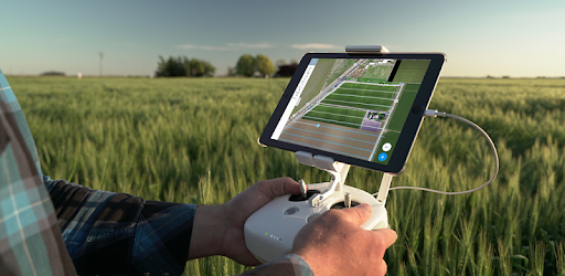
Drone Mapping Software | Drone Mapping App | UAV Mapping | Surveying Software | DroneDeploy
From drone fleet management to complete site documentation and analysis, we have your back every step of the way. Save time and money Harness the power of visual data to cut unnecessary scheduling hours and shave money off the budget.
www.dronedeploy.com
DroneDeploy - Flight App DJI
The free DroneDeploy app is the leading software for drones with millions of flights flown by over 100,000 pilots! FLIGHT APP Download the DroneDeploy app to upgrade your drone with autonomous and free flight capabilities for automated capture in just a few taps. Your drone will fly itself! Anyone...
apps.apple.com

DroneDeploy - Mapping for DJI - Apps on Google Play
DroneDeploy is the leading cloud software platform for commercial drones, and is making the power of aerial data accessible and productive for everyone. The free DroneDeploy app provides easy automated flight and data capture, and enables you to explore and share high-quality interactive maps, orthomosaics and 3D models directly from your mobile device.
play.google.com
UAV Forecast for DJI Quadcopter & UAV Drone Pilots - Apps on Google Play
When will it be good to fly your quadcopter? See the weather forecast, GPS satellites, solar activity (Kp), No-Fly Zones and flight restrictions, all in one convenient tool. Perfect for DJI Spark, Mavic, Phantom, Inspire, 3DR Solo, Parrot Bebop drones and many other Unmanned Aerial Vehicles and Systems.
play.google.com

3DF Zephyr - photogrammetry software - 3d models from photos
BEYOND 3D MODEL Get true orthophotos, Digital Terrain and Surface models (DTM, DSM), stats and project reports. Perform CAD drawing and generate sections, paths and contour lines. Measure anything. Then, export your data to the file format that suits you best.
www.3dflow.net
Professional Edition
Photogrammetric triangulation Processing of various types of imagery: aerial (nadir, oblique, close-range, satellite. Auto calibration: frame (incl. fisheye), spherical & cylindrical cameras. Multi-camera projects support. Scanned images with fiducial marks support. Digital elevation model: DSM/DTM generation Digital Surface and/or Digital Terrain Model - depending on the project.
www.agisoft.com

Online Store
Licensed copy of Metashape Standard Edition can be upgraded to Metashape Professional Edition. For educational purposes special prices are available. Please see Educational licenses page.
www.agisoft.com
Professional photogrammetry and drone mapping software
A unique suite of photogrammetry software for drone mapping. Capture images with our app, process on desktop or cloud and create maps and 3D models.
www.pix4d.com

SimActive | High-End Mapping Software
High-End Mapping Software | Rapid processing of imagery from drones, aircrafts and satellites. Start mapping today with Correlator3D.
www.simactive.com
Maps Made Easy - Home
All jobs 250 Points or less are free! All new accounts get 500 Points as a starting balance. Enough to map 800 acres. Need help getting up in the air? Drones Made Easy customers get tons of free processing. Details.
www.mapsmadeeasy.com
ply, vrml abc, obj geotiff, ply, xml MVE ply obj, ply ply ply, obj, fbx, pdf 3D, u3d, dae, pts, ptx, xyz, txt, las, e57 asc, cl3, clr, e57, fls, fws, isproj, las, pcg, ptg, pts, ptx, rds, txt, xyb, xyz, zfs, zfprj fbx 3ms, 3sm, kml, dae, fbx, obj, dae, stl .asc, geotiff, .las ENH, NEH, DXF, PLY, PDF, LAS, PNG, GTIFF dxf, GeoTIFF, las, obj, xyz All currently known image formats TXT, CSV, PTS, LAS, PLY, DXF, KML img, igg, ovr. l, noaa, rpf, ddf, dem, til, dt2, ecrg, hdr, xml, ecw, url, ant, dig, alg, ers, gis, lan … PLY, OBJ, LAS 3ds, 3dm, dxf, igs, kml, kmz, las, ma, ms, obj, pts, byu, facet, iv, ply, stl, txt, wrl obj, fix, dxf, las, las, kml, tif, osgb, slpk, shp jpg, png, XYZ, XYZRGB, tiff, bmp, dib, rle, jpeg, jpe, jfif, exif, exr, tif, wdp, jxr, dds, KML, KMZ, obj, ply, partlist, fbx, dxf, dae, bvh, htr, trc, asf, amc, c3d, aoa, mcd, wmv, mp4
GeoTIFF, png, las, obj